

Global MLG Structure Dataset
The Global MLG Structure Dataset maps the multilevel governance organization of public sectors in countries around the world, providing a standardized, open source classification of MLG structures, enabling coherent comparative analysis of multilevel governance systems worldwide.
Why do we need a Global MLG Structure Dataset?
The analysis of decentralization, federalism, and multilevel governance draws on data from many disciplines and institutions, but there is no common standard for classifying levels of government. As a result, the same government level in a country may be treated as a local government level by one dataset and as a regional level by another. Similarly, some data sets focus exclusively on regions, while others focus on the local level, and yet other sources may not clearly identify which exact government level their data represent. These inconsistencies make it difficult to analyze or compare multilevel governance data across countries or sources.
A standardized, open source classification of MLG levels provides a common framework for connecting otherwise fragmented datasets and enabling coherent comparative analysis.
Explore the Data Set
MLG Country Profiles
The Global MLG Structure Dataset provides a standardized description of the institutional architecture of multilevel governance in each country resulting in a standardized MLG Country Profile. Its starting point is a consistent functional classification of government levels as national, regional, or local, rather than relying on country-specific terminology or simply assuming that first- and second-order administrative divisions correspond to regional and local government.
Importantly, the framework does not assume a simple three-tier structure of one national, one regional, and one local level. Countries may have no regional level, more than one regional or local level, or several nested local tiers. Multiple levels within the same functional category are therefore identified sequentially—for example, L10, L20, and L30 for progressively lower local levels. This allows the framework to represent relatively simple systems as well as complex subnational institutional arrangements, where several local governance tiers coexist below and alongside each other.
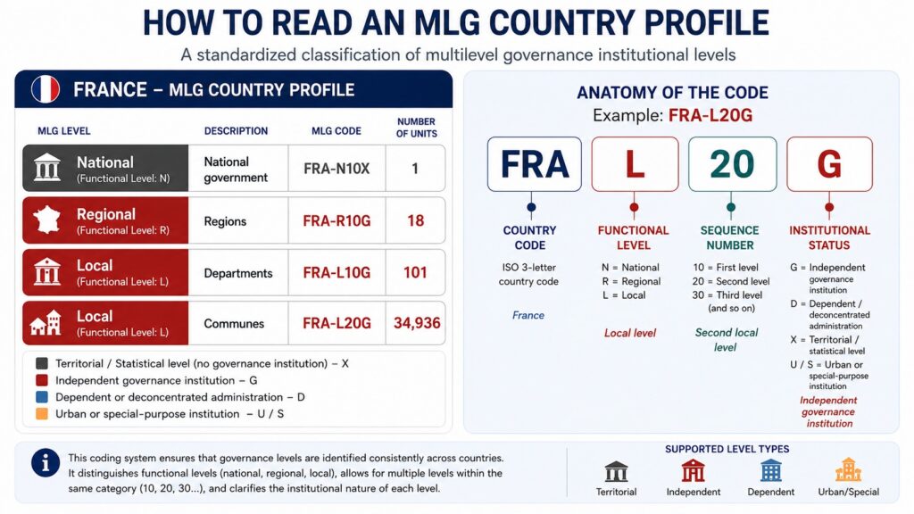
A key contribution of the MLG Country Profile methodology is that it distinguishes territorial jurisdictions and administrative boundaries from governance institutions. A territorial subdivision is not automatically treated as a governance level: the framework identifies whether each relevant level consists primarily of independent governance institutions (i.e., regional or local governments, or hybrid institutions), dependent or deconcentrated administrative institutions, or merely territorial/statistical subdivisions without a distinct institutional structure. This addresses an important weakness in conventional administrative-boundary classifications, since similarly named institutions (provinces, districts, or counties) may represent autonomous governments in one country, deconcentrated administrations in another, and largely statistical territories in a third.
The resulting Country Profile therefore provides a common institutional map onto which other MLG information can be consistently attached. For every relevant level it records its functional position, institutional status, name, number of units, correspondence with territorial-administrative classifications where applicable, and institutional depth; distinct urban or special arrangements can be identified separately where necessary. This common architecture makes it possible to connect political, administrative, fiscal, functional, electoral, and geospatial datasets that otherwise use inconsistent definitions of what constitutes a “regional” or “local” government.
Browse MLG Country Profiles
Provisional MLG Country Profiles are available below: